Southern regions nurtured languages
by Tim de Chant. Per Square Mile, January 10, 2012Southern regions nurtured languages
(which references this article: A latitudinal gradient in the density of human languages in North America [PDF])
This blog post investigates how the density of pre-contact Native American languages increases as the latitude decreases, mirroring the number of animal species in those same areas. The sheer variety of languages increases exponentially from about 40° North until at least 8° North (the southern limit of this analysis). One possible explanation to this phenomenon is the corresponding increase of varied habitats. The reasoning behind this is that as habitats become more varied, resources also increase, giving way to smaller groups of animals and humans who can survive in isolation. The author concludes by relating this to the fact that so many languages are dying out as we push for globalization. He makes the connection that as our population increases, our resources decrease, thereby creating the same type of environment that forces us to work together in order to survive. Communication is one of our best tools to encourage cooperation.
This article relates to the chapter: Language. I found this article to be fascinating, especially the fact that the pattern of increase matches the density of animal species. Although, I wish that a similar study could be made of the languages of the rest of the world in relation to habitat as well as latitude. The Americas (at least in the southern areas!) have a tremendous number of dialects and languages even though both continents together only contain three language families. I believe that this stems from the way in which the Americas were originally settled. This article also proposed a reason behind the disappearance of our unique languages as we move towards globalization. Rather than expecting all of us to continue speaking only our culture’s “hearth tongue”, we should encourage a universal language as well as a way to keep our individuality intact. The Native American sign languages are a great example of this. Whole groups of tribes could communicate with these signs while keeping their own unique languages for speaking. It is much harder to understand a foreign accent than it is to understand a foreign hand signal.
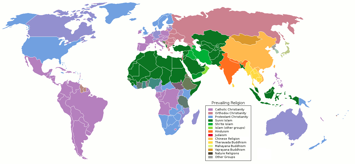
Synopsis of Religion in the Early Republican Primaries
by Pew Research Center. The Pew Forum on Religion and Public Life, March 2, 2012Synopsis of Religion in the Early Republican Primaries
Every election year, religion plays a large part in people’s decisions at the polls. This year, Mitt Romney, a Mormon, is aiming for the republican delegation once again. Romney has received significantly less support from white, evangelical Christians than other voters in every state which has such information available. On average, Romney has received about 15 percentage points more support from non-evangelical voters than from the evangelical. Romney has also attracted the Catholic vote, whereas Santorum (who is Catholic) has yet to win the majority of the Catholic vote in any state. In the Mormon dominated states that have so far held their primaries, Romney is the clear winner among Protestants, with the percentage of Mormons (which are grouped as Protestants in the exit polls) voting for Romney being as high as 96%. In Nevada and New Hampshire, there were enough religiously unaffiliated voters to analyze, and they favored Ron Paul.
This article relates to the chapter: Religion. The United States is home to a large assortment of religions. According to our textbook, almost 80% of us are Christian. This year’s republican primaries include Romney, a Mormon; Santorum, a Catholic; Gingrich, also a Catholic; and Paul, a Baptist. Of these candidates, Romney is the most interesting to look at religiously. In the United States, Mormons have a rocky history of discrimination and persecution from the Evangelical Christian community. When the Republican party was created, it was expressly anti-Mormon. Today, a majority of Mormons identify as Republican, but they are still not entirely accepted by the rest of the party. This article is a perfect example of the localization of attitudes towards various religious affiliations, as well as the religious distributions in the United States. The southern states, which hold a high percentage of Evangelicals, did not, as a whole, vote for Romney, where those who live near the Mormon regions surrounding Utah (which they settled in the mid 1800s) were much more likely to vote for Romney.
Bid to censure Lanka at UN puts India in a fix
by TNN. The Times of India, March 14, 2012Bid to censure Lanka at UN puts India in a fix
The UN’s Human Rights Council made a motion to censure Sri Lanka over their actions against the terrorist group, Liberation Tigers of Tamil Eelam (LTTE) during the last few weeks of the conflict between LTTE and the Sri Lanken government. In India, the Dravidian political party (DMK) has been pushing for censure, while the more neutral leaders (including the Prime Minister) see such a move as merely aggravating an old wound without accomplishing anything. India has a policy to never vote on country specific resolutions, but in this case, the ethnic ties between the two countries make this almost impossible.
The article concluded with India’s claim that this issue would be better dealt with by the Sri Lanken government, and other neutral parties working towards redress rather than a harsh UN censure.
This article relates to the chapter: Ethnicity. The ethnic ties that bind the Tamil of Sri Lanka to the Dravidian Hindus of India together is part of the reason that the civil war was as drawn out as it was (since India contributed arms). It makes complete sense that they would also want some sort of admission of wrong-doing, some punishment and retribution in return. The Tamil might not be powerful enough to gain this by themselves, but it seems that their Indian cousins are more than happy to step up to the plate for them. It shows that despite country lines (no matter how old), family is family and we feel a tie to those who are like us.
I chose this article because it caught my eye since I had chosen this as my religious conflict in the discussion the previous week.
Bahrain and Belarus named ‘enemies of the internet’
by BBC Journalist. BBC News, March 13, 2012Bahrain and Belarus named 'enemies of the internet'
‘Reporters Without Borders’ (RWB) is a non profit organization devoted to protecting and informing international journalists. In this article, it was announced that Bahrain and Belarus have both been added to RWB’s list of ‘Enemies of the Internet,’ which includes countries that “restrict net access, filter content, and imprison bloggers.” The article covers some of the tactics used by these countries to restrict the freedom of information through the Internet, especially concerning political dissent. Mention is also made of the countries who are bordering on overstepping the bounds that freedom of information require. This includes countries like Australia (for creating a blacklist that blocks any site that the Australian government does not approve of), France, Egypt and India.
This article relates to the chapter: Political Geography. One of the major distinctions between countries is the government that controls the area within the borders. When dealing with an international concept such as the Internet, each government chooses to control it (or not) in a different way. The most oft cited reason for restricting internet access is to also restrict communication. The Egyptian riots of this winter are an example of what dissenters can do to build up a revolution using the Internet. I can see how this would be frightening, especially in countries that do not have good relations with all (or many) of their citizens.
I chose this article because I am, or used to be, in the tech field, and so I am always interested in how the different parts of the world are coping with this new technology. I also chose this article because it deals with a form of communication that cuts through the borders. The network connections don’t care which side of a line you are standing on, and neither does the free sharing of information. I hope that we have all gotten a good taste of this freedom, and will fight to keep it for future generations.
See and Hear Last Speakers of Dying Languages
by Ker Than and Chris Rainier. National Geographic, February 17, 2012See and Hear Last Speakers of Dying Languages
A new project has been announced that will attempt to capture the Earth’s disappearing and endangered languages in digital format. So far, they have begun to document eight languages (from places such as Mongolia, India, and Paraguay) and have collected 32,000 word entries as well as 24,000 audio recordings. They are working on adding more words as well as more languages to their “talking dictionary.” Although other projects exist, this is geared towards recording the languages of people who do not have the technology to record their language themselves. The purpose of recording these languages is not to provide a way for students to learn the language, but as a supplement to more formal instruction (including grammar).
In Matukar, Papua New Guinea, a small fishing village, there are about 600 speakers of the language, Matukar Panau left. The villagers requested that their language be placed online, even though none of them had ever used the Internet, and the village did not even have access to electricity.
Another language that is being preserved is the Remo language of India, which is of particular interest because of its ancient, pre-Hindu roots. There are few ways to look back into the past, and language is one of the most powerful. As one of the researchers said, “humans lose a unique lens upon the world every time a language dies.” This dictionary project might not be enough on its own to revive a language, but it is one small way that we can preserve these windows into our past and our humanity.
This article relates to the chapter: Language. Languages die and are born with the people who speak them. If no one is left to speak a language, there are few ways to completely retrieve that language for use again. Even in the case of Hebrew, there are many questions and value judgments that had to be made, and there is no guarantee that speakers of modern Hebrew are speaking something even close to the original language. That process was also helped along by the existence of Yiddish, from which some of the vocabulary and grammar rules could be extrapolated. In the case of Matukar Panau, or any of the other languages mentioned in this article. they did not have a large enough sphere of influence to leave but the trace of a memory behind when the last native speaker passes on. Should we feel that by creating an audio recording of a language that we are ‘saving’ it? If we are truly concerned with the preservation of culture and language, is this the best we can do?
I picked this article because of the pretty pictures and the included audio files of the spoken languages. I mean, honestly, who can resist a little multi-media?


.jpg)